Background of the B4063

Stay up to date with what's happening by signing up to our scheme email bulletin.
The B4063 Gloucester to Cheltenham Cycle Improvements Scheme was developed with the strategic aim to create a continuous link between the major areas of Gloucester and Cheltenham and the communities in between. This was initially developed by National Highways (formerly Highways England) who have designated a series of ring-fenced funds to invest in cycle infrastructure.
A study was undertaken in 2015/16 to assess the most continuous, direct, comfortable, safe and attractive route for cyclists of all abilities avoiding the A40 strategic corridor. The A40 was discounted due to its lack of suitability for cyclists due to high traffic speeds, motorway junction and accident history.
National Highways completed a preliminary design which highlighted the benefits and suitability of the B4063 as the preferred route. This was passed to Gloucestershire County Council and their design team at Atkins for further development. Detailed design was completed during the 2020/21 financial year and construction commenced in 2021/22.
Vision
The B4063 Gloucester to Cheltenham Cycleway is part of the wider ambition for a Gloucestershire Cycle Spine, extending across the county from Stroud in the south to Bishop's Cleeve in the north. The Cycle Spine will create a significant cycling and walking network across the county and represent a step-change in terms of quality and connectivity. Gloucestershire Cycle Spine Map (PDF, 874.2 KB).
As a result of successful applications to National Highways and both the Levelling Up Fund and Active Travel Fund, the sections from Bishops Cleeve to Cheltenham and through Gloucester City Centre are also being developed.
It will give a continuous route for cyclists and make cycling and sustainable travel more appealing; helping to get people out of their cars, improving the amount of traffic in the area and addressing, in part, the aims of the Gloucestershire Local transport plan (PDF, 10.6 MB).
The new cycle path will be accessible to all, aiming to improve health and wellbeing in the community while reducing Gloucestershire’s carbon emissions. See how the Council is tackling climate change and creating a greener, healthier more prosperous Gloucestershire as part of a four-year strategy building back better in Gloucestershire.
The route will also help people reboot their commute, connecting the communities of Churchdown, Innsworth and Staverton to public transport hubs in both Gloucester and Cheltenham and connect with different workplaces, such as Gloucestershire Royal Hospital and University of Gloucestershire campuses. It will also maintain the current bus provision with improved bus stops and facilities along the route.
The Route
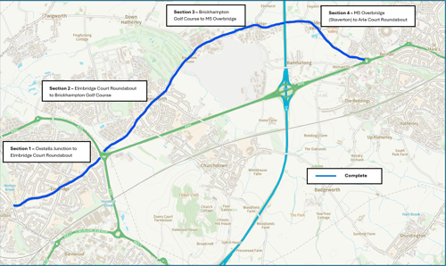
The now completed route forms an 8 km (5 mile) cycleway between Oxstalls Junction via Longlevens, Churchdown and Staverton. This will link to future cycle spine schemes towards Gloucester city centre in the west and connects to the completed West Cheltenham scheme at Arle Court Roundabout to the east.
The route is divided into the following sections:
- Section 1 - Oxstalls Junction to Elmbridge Court Roundabout (completed June 2025)
- Section 2 - Elmbridge Court Roundabout to Brickhampton Golf course (completed September 2024)
- Section 3 - Brickhampton Golf course to M5 Overbridge (completed April 2024)
- Section 4 - M5 overbridge (Staverton) to Arle Court Roundabout (completed January 2023)