A46 road closure - South of Painswick

UPDATE: August 29th 2024.

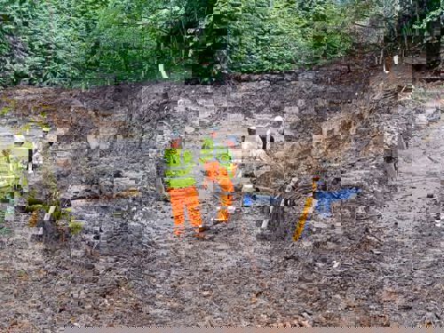
We have managed to tie in the existing gully pipe into our 1200mm manhole, reshape the ground around it with clean stone and the excavated soil, whilst also building a headwall upstream. Next week the company Sapphire will complete the pipe lining on Tuesday & Wednesday, with the fencing to be finished on Thursday/Friday. 

We will reopen the carriageway back to two-way signals from the end of 30th August. This is to allow for some short-term monitoring over the next couple of weeks to allow monitoring of the cracking present on the southbound lane. If no further movement is noted we will resurface this lane mid-end September with the aim of removing all Traffic management whilst we continue to monitor the site longer term.

UPDATE: August 2024 

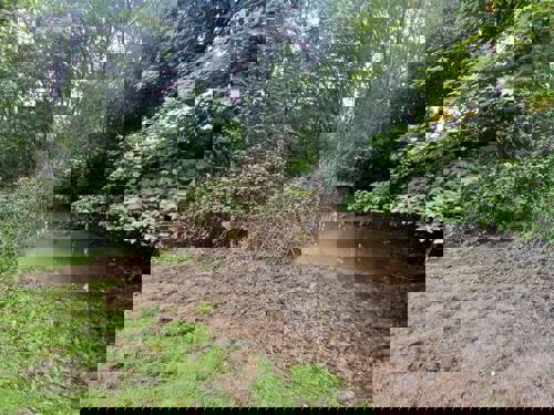
As per our previous communications this planned closure was to undertake investigation of the culvert with the hope that any repairs could also be undertaken during this period. Given the silt build up in the flooded area of the field, safely locating the culvert was proving trickier than planned and required a more extensive excavation. We made the difficult decision to extend our current closure to continue working now rather than having to return later and extend the inconvenience into another period. The culvert has now been located and plans to create the new drainage elements connecting to the existing culvert under the A46, as well as regrading the land located around it, are underway. The closure is officially until the 30th August, however we are hopeful we should be complete before this date. 

UPDATE: July 2024

Between 29 July - 16 August 2024, a road closure will be in place to allow us to carry out investigation and repair work.

What will be in place?

A road closure will be in place 24/7 along the A46 Painswick road, between the junction with the A4713 and Pincot Lane, as pictured below. We appreciate road closures are inconvenient, but to keep everyone safe, in this case it is necessary. We have planned the work so we can be in and out as quickly as possible. The work is planned to take place between 29 July - 16 August 2024 but because elements of the work are weather dependent the dates could be subject to change.

Diversion

A diversion route will be signposted (pictured below). Please note the diversion route is designed to include a similar class of road to the A46, to accommodate larger vehicles. We ask all drivers to follow the signed diversion route to avoid congestion on smaller local lanes. 

Map showing diversion route

About the work taking place

We will undertake an investigation of the culvert running underneath the carriageway. Where possible we will also use the closure to carry out any other repairs required. This is a continuation of work started previously during the winter in response to cracking that developed in the road. You can read about the issue in more detail below on this web page.


A road closure was in place on the A46 at the Pincot Lane / Wragg Castle Lane junction, approximately 2.5km south of Painswick.

On 7 March 2024 a hole was found beneath the road and temporary traffic lights were installed. Technical inspections were carried out and on 11 March and the road was closed for safety reasons as cracks have also been found at this location.

This planned closure was to undertake investigation of the culvert with the hope that any repairs could also be undertaken during this period. Given the silt build up in the flooded area of the field, safely locating the culvert was proving trickier than planned and required a more extensive excavation. We made the difficult decision to extend our current closure to continue working now rather than having to return later and extend the inconvenience into another period. The culvert has now been located and plans to create the new drainage elements connecting to the existing culvert under the A46, as well as regrading the land located around it, are underway. The closure is officially until the 30th August, however we are hopeful we should be complete before this date. 

This planned closure was to undertake investigation of the culvert with the hope that any repairs could also be undertaken during this period. Given the silt build up in the flooded area of the field, safely locating the culvert was proving trickier than planned and required a more extensive excavation. We made the difficult decision to extend our current closure to continue working now rather than having to return later and extend the inconvenience into another period. The culvert has now been located and plans to create the new drainage elements connecting to the existing culvert under the A46, as well as regrading the land located around it, are underway. The closure is officially until the 30th August, however we are hopeful we should be complete before this date. 

The diversion route is signposted. The route is designed to be suitable for larger vehicles that would have used the A46. Please note that smaller lanes near the road closure can not accommodate diverted traffic, so we recommend all drivers use the signposted diversion route.     

Map of diversion route

  • We will continue to connect new drainage to the old culvert, building up the levels to be able to construct a new head wall and catch pit to reduce the likelihood of any issues in the future.
  • We will complete drainage connections and regrade the land around to suit. We will replace all fencing on the site. 
  • We will then undertake a site clear up with installation of the two way temporary signals, ready to remove the full road closure. 
  • Updates will be published on this web page and on social media when further information is available.


We have successfully located the culvert, however the culvert was not in the location we were expecting. This has lead to further accommodation works to successfully connect into the culvert. We also completed a CCTV survey of the drainage and culvert exposed to enable us begin the connection to the culvert. The CCTV also confirmed that the exposed clay pipe is the only inlet into the box culvert, passing beneath the road. Patches are to be installed to repair the clay pipe. 


We have successfully located the culvert, however the culvert was not in the location we were expecting. This has lead to further accommodation works to successfully connect into the culvert. We also completed a CCTV survey of the drainage and culvert exposed to enable us begin the connection to the culvert. The CCTV also confirmed that the exposed clay pipe is the only inlet into the box culvert, passing beneath the road. Patches are to be installed to repair the clay pipe. 

  • Ground investigation works completed.
  • Equipment removed from site.
  • Road open with traffic lights from approximately 4am Thursday 18 April.
  • Ground investigation works completed.
  • Equipment removed from site.
  • Road open with traffic lights from approximately 4am Thursday 18 April.
  • Ground Investigation (GI) is progressing reasonably well on site, with the last borehole currently being drilled in the carriageway. Re-grouting to fill the holes will then be undertaken to complete this activity towards the end of this week or beginning of next. Unfortunately, we have had to cancel the boreholes planned for the field locations either side of the A46 due to the ongoing rainfall - the ground conditions are too wet and unsafe for the equipment. The need to return to install these will be assessed later following taking readings from the installed equipment which will show any ground movement and determine the need for further locations to gather additional information.

  • All de-watering equipment is being decommissioned and removed from site, again with the view to returning during the drier summer months to further investigate and undertake any required repairs to the culvert under the A46 and Pincot Lane.
  • Trial holes completed and Ground Investigation started on site. This is a process of drilling boreholes (using the drilling rig pictured below) into the ground and installing ground monitoring equipment. The ground monitoring equipment will allow us to closely monitor any ground movement going forwards, with minimal disruption to the public, and it will aid the design of any repairs to be undertaken to stabilise the embankment and road.
  • Drainage of the water from the flooded field to the West of the A46 was undertaken but unfortunately this only uncovered 500mm+ of silt meaning that the culvert below the road could not be located and is very likely almost completely blocked. This investigation will need to be put on hold for now and will recommence during the summer. A temporary road closure will be required during the summer due to the size of the water pump and other plant required for the operation and will of course be advertised in advance.

Photo of rigging on site

  • Trial trench investigations continue to establish utility service locations (see photo below). Severn Trent Water have also visited the site to confirm the water main location. This information is required to ensure that we do not disturb the service during Ground Investigation drilling planned to start 2 April.
  • Gloucestershire County Council engaged a Ground Investigation contractor to start works on 2 April for 2 weeks. This will involve drilling boreholes at a number of locations on the A46 and surrounding fields to determine the ground conditions and depths of failures causing the landslip and cracking on the road.
  • A specialist contractor was consulted with regards to pumping of water flooding the field to the west of the A46. The equipment has now arrived on site and the drainage will take place Wed 27 – Fri 29. This may cause some short delays to traffic using Pincot Lane as the water will need to be pumped through pipes over this road to reach the watercourse below. If the area can be de-watered successfully this will provide the best chance for inspection of the culvert under the A46 to establish whether there is any collapse or defects causing the voiding. The de-watering will also relieve the pressure being applied to the already saturated embankment.
  • Additional signage confirms “Businesses open as usual” to support businesses along the route into Painswick. “Unsuitable for diverted traffic” signs have also been installed on the minor roads to deter vehicles using these rather than the official diversion route.

Photo of digger and fencing across the A46 road

Photo of road signs

This week we continue to dig trial trenches to examine the carriageway below the surface. Significant cracks have been found, as pictured. We are also investigating the options for removing standing water that has accumulated in the field to the west of the A46 and is saturating the embankment on which the A46 stands.

Photo of trial trench

Survey crews arrived on site to determine the condition of the drainage system and investigate the extent of a holes beneath the road. This week we also started to dig trail trenches to examine the condition of the road beneath the surface. The picture below shows evidence of cracking and movement within the edge of the carriageway:

Photo of void beneath the road