B4058 Rushmire Hill

📽️ Rushmire Hill Reopens – A Video Update with Cllr Harris

We’re excited to share a special video update with Councillor Harris, highlighting the much-anticipated reopening of Rushmire Hill. In this short film, Cllr Harris walks us through the improvements made, the community benefits, and what this milestone means for the local area.

🎉 Whether you're a resident, visitor, or simply curious about the transformation, this video offers a firsthand look at the journey and the future of Rushmire Hill.

👉 Watch now to see how this revitalized space is ready to welcome you back!


 đźš§ Rushmire Hill is now open! đźŽ‰ We’re pleased to announce that all works are now complete and the road is fully open to traffic. Thank you for your patience during the construction period. Please note, there will be a one-night closure on Monday 28 July 2025 to carry out final defect works—after that, it’s smooth driving ahead!

The B4058 carriageway on Rushmire Hill has been affected by cracking and subsidence since it was first inspected in September 2016. Since this first inspection, Ground Investigation has been undertaken in 2018 and 2023 to monitor movement and install groundwater and ground movement monitoring equipment.

The site has deteriorated over the last seven years and has been resurfaced multiple times. The cracking at the site runs parallel to the verges and is mostly located along the northbound lane of the B4058. There is also cracking in Old London Road and the southbound lane of the B4058. Cracking and areas of resurfaced patches, which indicate locations of historic cracking, extend across the full length of the site.

The B4058 is a key route within the county and connects Wotton Under Edge with areas to the north and west, such as Nailsworth, Stroud and Tetbury.  Intervention now will prevent further movement and the risk of more catastrophic failure.

The B4058 carriageway on Rushmire Hill had been affected by cracking and subsidence since it was first inspected in September 2016. Following this initial inspection, Ground Investigations were carried out in 2018 and 2023 to monitor movement and install groundwater and ground movement monitoring equipment.

Over the past seven years, the site had deteriorated and was resurfaced multiple times. Cracking, primarily along the northbound lane of the B4058 and also present in Old London Road and the southbound lane, was observed to run parallel to the verges. Resurfaced patches, indicating historic cracking, extended across the full length of the site.

As a key route within the county, the B4058 connects Wotton-under-Edge with areas to the north and west, including Nailsworth, Stroud, and Tetbury. Intervention at this stage was necessary to prevent further movement and reduce the risk of more severe failure.

What Did We Do?

Based on the collected data, an engineering assessment and repair options report was compiled. Although monitoring did not fully confirm a deeper-seated failure mechanism, a conclusive assessment would have required significantly deeper ground investigation—beyond the 17.5m depth of existing boreholes—and would have exceeded available budgetary resources.

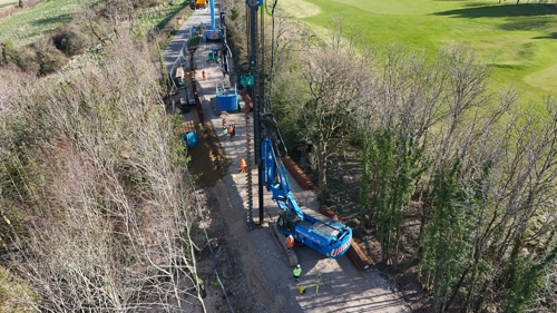
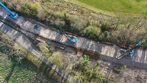
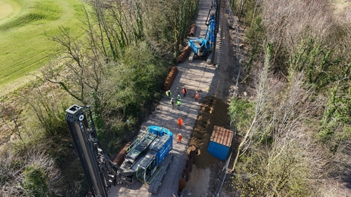
A medium-term solution was therefore implemented, involving the installation of a 255m-long, 9m-deep sheet pile wall to support the road and stabilise the slope. This approach was assessed as the most practical remediation option. Given the natural topography underlying many roads in Gloucestershire, similar risks are managed across the network. Post-construction, the road will continue to be monitored for further ground movement.

Works Progress

The contractor, Montel, mobilised to site and began the project as scheduled on 6 January 2025.

The arrival of the piling rig, crane, and sheet piles marked a significant milestone, and piling operations officially commenced shortly thereafter. These works were essential to stabilise the road and ensure its long-term safety for the community. The road remained closed during this period, with a diversion route in place.

We’re pleased to confirm that the works have now been completed and Rushmire Hill is fully open. Thank you for your patience and support throughout the project.

Please note: there will be a one-night closure on Monday 28 July 2025 to carry out final defect works.

Why?

We are responsible for maintaining roads across the county. This is one of several sites identified for repair to ensure the safety of road users and to reduce future maintenance costs.

To report a problem on your highways please use our Report It form.

Further information

If you have any further questions, please contact us by emailing majorprojects@gloucestershire.gov.uk


       The site has exhibited defects in the surface of the highway, since it was first inspected in September 2016, and undergone various phases of resurfacing and slope monitoring since.

       The site is also subject to frequent monitoring to ensure the roads safety. This is conducted every 6 months which require road closure.

The scheme cost is estimated to be ÂŁ1.9 million split between investigation and design at ÂŁ0.5 million and construction at ÂŁ1.4 million.

The scheme cost is estimated to be ÂŁ1.9 million split between investigation and design at ÂŁ0.5 million and construction at ÂŁ1.4 million.

From the collected data a report was compiled giving an engineering assessment and options for repair. Whilst the monitoring to date has not fully confirmed any deeper-seated failure mechanism, a conclusive assessment would require significant further ground investigation, beyond the 17.5m depth of the existing boreholes, with any remediation options exceeding the budgetary resources available.

A medium-term solution has therefore been developed, which comprises a sheet pile wall approximately 255m long and 9m deep that will support the road and stabilise the slope in the medium term and has been assessed at the most practical remediation option. The natural topography underlying many of our roads in Gloucestershire is such that we manage similar risks across our entire network. We will continue to monitor the road for further ground movements following construction.


A public drop-in event will be arranged for early December 2024 to be held at a location in Wotton Under Edge (TBC). Once the details of this event have been confirmed residents and businesses will be invited to meet the contractors, as well as the project team, and ask any questions they have.

If you have any further questions, please contact us by emailing majorprojects@gloucestershire.gov.uk

The project is being funded by Gloucestershire County Council and the Department for Transport.

The project is being funded by Gloucestershire County Council and the Department for Transport.

Yes, site survey work has been carried out to assess potential environmental impacts, and the scheme is being designed to take these into account. The environmental assessment will consider all the potential environmental impacts of the scheme and recommend how these can be alleviated.

Yes, site survey work has been carried out to assess potential environmental impacts, and the scheme is being designed to take these into account. The environmental assessment will consider all the potential environmental impacts of the scheme and recommend how these can be alleviated.

Construction will start on the 6th January 2025 and is anticipated to last approximately 6 months. This will be confirmed by the contractor.

Construction will start on the 6th January 2025 and is anticipated to last approximately 6 months. This will be confirmed by the contractor.

These funds are specifically allocated for projects of this type and are not available for routine road maintenance.

These funds are specifically allocated for projects of this type and are not available for routine road maintenance.

When the road is closed, we will be maintaining access for residents and will be working hard to minimise disruption to the travelling public.

We have followed national guidelines for the diversion route and road signage, and will continue to monitor traffic in the local area and where appropriate provide additional signs. We strongly recommend vehicles and cyclists use our signed diversion when it is in place as it is suitable for all road users and will help avoid local congestion.

As part of the construction tender process, we will set out requirements for methods of working. This will set out the approach to minimise and mitigate the impacts of noise/pollution etc. during the construction period.

As part of the construction tender process, we will set out requirements for methods of working. This will set out the approach to minimise and mitigate the impacts of noise/pollution etc. during the construction period.