
Network Rail bridge – Badgeworth Road/Lane – road closure
Update: 17 December 2024 The road is now open.
Director of Transport and Highways Jason Humm said: 'We are very pleased to re-open Badgeworth Road bridge in time for Christmas. Network Rail have carried out extensive work to stabilise the embankments and make the road safe for use again. This was a challenging job and we thank local residents for their patience during the works.'
What has happened
- We have been monitoring the Network Rail embankments leading towards the Rail Bridge.
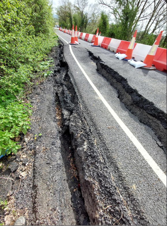
- During an inspection it was observed that the bridge approach embankments were beginning to fail.
- A season of unprecedented rain fall is considered to be a major contributing factor in the failure of these embankments.
What is in place?
- As a result of our inspection and following analysis of the failed embankment by geotechnical engineers the decision to close the road was taken to ensure the safety of all highway users.
- Options to mitigate the disruption were looked at, including half closure of the carriageway and the installation of two-way temporary traffic lights.
- However, due to the extent of the failure, the narrow width of the road and minimal space along the verges, a full road closure for safety reasons was deemed necessary and remains in place, the edges of the road are currently unstable (as pictured above).
What have we been doing?
- The bridge approach embankments that have failed are the responsibility of Network Rail, and therefore as a County Council we have limited tools to expedite the process of remediating this failure.
- We have continued to liaise with Network Rail to ensure they are fully aware of the impacts the closure of this bridge has on the road network, particularly highlighting the key connectivity link that this road provides to local residents and the broader community.
- We have established a diversion route.
- A diversion route must use a road that has the same classification as the road that has been closed. In this case Badgeworth Lane and Cold Pool Lane are both Class 3 roads so the diversion route that has been set is appropriate.
- We are mindful that this places additional traffic along Cool Pool and Badgeworth Lanes and our local highway and network management teams continue to monitor this and are looking at options for mitigation measures.
Is there access for pedestrians or cyclists?
For safety reasons there is a full road closure in place with no access for pedestrians and cyclists.
Bus information
Please visit the Stagecoach website for updates about bus services 97 and 98.
How long will this take and when will the road be opened?
- The raised embankments are in the ownership and responsibility of Network Rail.
- Network Rail have now completed the inspections and design works for the raised embankments which Badgeworth Road is supported by.
- This has been a very challenging undertaking and Network Rail are now able to provide a current a timeline for the remedial works to begin, and this timeline is set out below.
Update: December 2024
- Network Rails team have been on site since 25 November 2024.
- They have now started piling works, as pictured below.
- These works are to assist with the stabilisation of the embankment and to facilitate the remedial works.
- The works are scheduled to take around 7-9 working days.
- The works are still on programme for completion before Christmas subject to the weather remaining fair and no unforeseen issues with the piling productivity.
- These works will include the repairs to the road surface.
- Both Network Rail and Gloucestershire County Council are all very keen to see the bridge reopened as soon as practicable as we are very mindful the importance it provides as a vital connectivity link for the local community.
- We continue to work alongside and support Network Rail to ensure that we communicate progress to all key stakeholders and the broader community via this web page.


Diversion
Please follow the signed diversion route.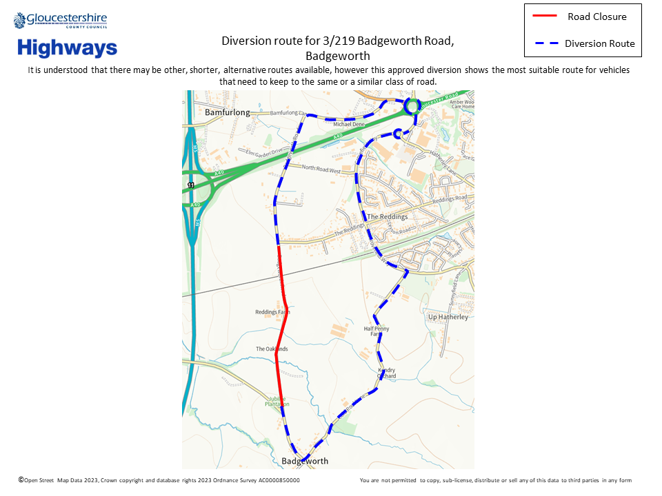
Further information
The bridge location using What3words is: ///simply.ends.fingernails