
Plan drawings and 3D visuals will be made available once the public engagement period begins. This is currently planned to take place later in the summer.
Route and overview
Walking, wheeling and cycling improvements between St Ann's Way / Bristol Road and Cole Avenue.
Route
The route will run between the St Ann Way / Bristol Road junction and Cole Avenue, linking into Tuffley Lane, and provide a direct connection to both recently completed and planned sections of walking and cycling improvements through Gloucester City Centre.
The proposed route travels along Stroud Road, King Edward's Avenue, The Oval, through Tuffley Park, Podsmead Place, Laburnum Road, Podsmead Road and alongside Cole Avenue where it will link to Tuffley Lane.
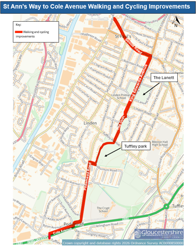
This route connects large residential areas with the city centre, Quays and Docks as well as key destinations including schools such as The Crypt School and Linden Primary School, and green spaces such as The Lannett, The Oval, Tuffley Park and Scott Avenue Open Space.
The route improvements will include:
- New segregated cycleway.
- Pedestrian route improvements.
- New and improved crossing facilities for cyclists and pedestrians, including new signalised crossings at junctions and at access points to Tuffley Park and The Lannett.
- Proposed new surfaced cycle and footway through Tuffley Park.
- Improved pedestrian access to public transport.
Overview
- Forms part of the wider Gloucestershire Cycle Spine, strengthening connections between housing and schools, parks, City Centre, Quays and Docks.
- Informed by planning and feasibility work, targeting a high-demand corridor where improvements can deliver the greatest benefits.
- Responds to a busy, constrained section, supporting competing movements including general traffic, buses, and local trips.
- Delivers infrastructure upgrades, segregated two-way cycleways, zebra crossings and junction tables to enhance safety and clarity.
- Addresses gaps in existing provision, which currently favour more confident users despite strong demand for walking and cycling.
- Improves access and inclusion, making the route safer and inclusive for a range of users supporting increased active travel.
Plan drawings and 3D visuals will be made available once the public engagement period begins. This is currently planned to take place later in the summer.
A public share event will be held at a local venue later this summer. This will provide an opportunity for anyone to come and view scheme information and plan drawings and speak to members of the project team.
Details of the event will be communicated in advance via this scheme webpage, Gloucestershire County Council social media channels and via a media release.
A period will follow the event for people to make comments on the scheme design.
A public share event will be held at a local venue later this summer. This will provide an opportunity for anyone to come and view scheme information and plan drawings and speak to members of the project team.
Details of the event will be communicated in advance via this scheme webpage, Gloucestershire County Council social media channels and via a media release.
A period will follow the event for people to make comments on the scheme design.
Stay up to date with what's happening by signing up to our scheme email bulletin.