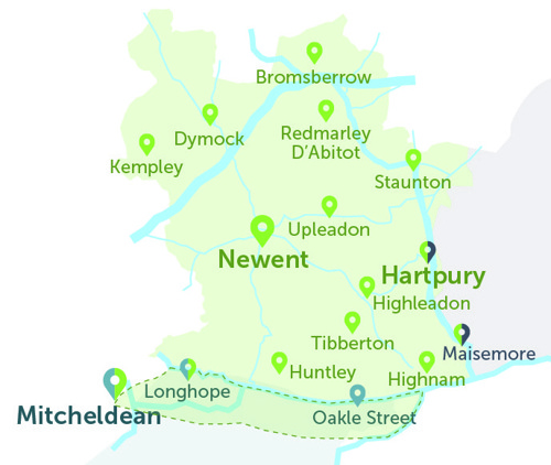
Newent Zone
New Robin area - the Newent Zone
- This green map is just a guide. To view all stops, please see list below.
- Hartpury and Maisemore are Robin stops for both the Newent Zone and for Tewkesbury District Robin areas. This is so people can get to these locations from the west or from the east.
- Mitcheldean and Longhope are Robin stops for both the Newent Zone and for the South Forest of Dean Robin areas. This is so people can get to these locations from the north or from the south.
- Our Newent Zone area overlaps into The Robin South Forest of Dean (to the south), see the area inside the dotted line. This is to allow residents in these overlapping areas to choose their preferred Robin service, and not designed for onward travel into a second Robin area.
Below is the full list of bus stops where you can be collected or dropped off, within the Newent Zone area of The Robin.
- For the interactive map, and to book a journey, please log into the website
- Use our App (download on Apple or Android)
- If neither of these are possible, please call our Robin team: 0345 263 8139 📱
- Regarding Robin stops that serve two Robin areas (there are four on the map above), the Robin is not designed for travel from one Robin area into another - we would advise against this. This would require two bookings and changing vehicle.
Stop name (Address) |
Village / District (A to Z) |
| Anthony's Cross (N) | Anthony's Cross |
| Anthony's Cross (S) | Anthony's Cross |
| Little Cugley (N). Anthony's Cross | Anthony's Cross |
| Little Cugley (opp. S). Anthony's Cross | Anthony's Cross |
| Solomon's Tump (NW). Birdwood | Birdwood |
| Solomon's Tump (SE). Birdwood | Birdwood |
| King's Head (W). Birdwood | Birdwood |
| King's Head (opp. E). Birdwood | Birdwood |
| Garage (NW). Birdwood | Birdwood |
| Garage (SE). Birdwood | Birdwood |
| Birches Lane Turn (NW). Botloe's Green | Botloe's Green |
| Birches Lane Turn (SE). Botloe's Green | Botloe's Green |
| Falconry Centre (opp. NE). Boulsdon | Boulsdon |
| Falconry Centre (SW). Boulsdon | Boulsdon |
| Commonfields Farm (NW). Boulsdon | Boulsdon |
| Commonfields Farm (opp. SE). Boulsdon | Boulsdon |
| Great Boulsdon Farm (opp. N). Boulsdon | Boulsdon |
| Great Boulsdon Farm (S). Boulsdon | Boulsdon |
| Stream Lane School (E). Brand Green | Brand Green |
| Stream Lane School (W). Brand Green | Brand Green |
| Fruit Farm (NW). Brand Green | Brand Green |
| Fruit Farm (opp. SE). Brand Green | Brand Green |
| White Hall School (opp. SE). Brand Green | Brand Green |
| White Hall School (NW). Brand Green | Brand Green |
| Village Hall (opp. NW). Brand Green | Brand Green |
| Village Hall (SE). Brand Green | Brand Green |
| Post Office (W). Bromsberrow Heath | Bromesberrow Heath |
| Post Office (E). Bromsberrow Heath | Bromesberrow Heath |
| Little Heath School. Bromsberrow Heath | Bromesberrow Heath |
| Sandfields. Bromsberrow Heath | Bromesberrow Heath |
| Memorial Hall (opp. E). Broom's Green | Broom's Green |
| Memorial Hall (W). Broom's Green | Broom's Green |
| Parking- behind Library Town Council | Bus driver break only |
| Bentleys (N). Castletump | Castletump |
| Bentleys (opp. S). Castletump | Castletump |
| Three Choirs (opp. NW). Castletump | Castletump |
| Three Choirs (SE). Castletump | Castletump |
| Oakle Street School stop (N). Churcham | Churcham |
| Oakle Street School (S). Churcham | Churcham |
| Bulley Lane Turn (opp. W). Churcham | Churcham |
| Bulley Lane Turn (E). Churcham | Churcham |
| Sainthill Lane (opp. W). Churcham | Churcham |
| Sainthill Lane (E). Churcham | Churcham |
| Business Park (W). Churcham | Churcham |
| Business Park (opp. E). Churcham | Churcham |
| Depot | Cinderford |
| Yew Tree Inn School stop (NW). Clifford's Mesne | Clifford's Mesne |
| Yew Tree Inn School stop (SE). Clifford's Mesne | Clifford's Mesne |
| Village Hall (adj. NE). Clifford's Mesne | Clifford's Mesne |
| Village Hall (opp. SW). Clifford's Mesne | Clifford's Mesne |
| Woodbar Cottage (N). Clifford's Mesne | Clifford's Mesne |
| Woodbar Cottage (opp. S). Clifford's Mesne | Clifford's Mesne |
| St Peter's Church (NE). Clifford's Mesne | Clifford's Mesne |
| St Peter's Church (SW). Clifford's Mesne | Clifford's Mesne |
| Compton Court (SW). Compton Green | Compton Green |
| Compton Court (opp. NE). Compton Green | Compton Green |
| Compton Green Nursery (E) | Compton Green |
| Compton Green Nursery (W) | Compton Green |
| Compton Green Nursery (opp. NW) | Compton Green |
| Compton Green Nursery (SE) | Compton Green |
| Crosshands Garage (NW). Corse | Corse |
| Crosshands Garage (SE). Corse | Corse |
| The Old Bakery (opp. NW). Corse | Corse |
| The Old Bakery (SE). Corse | Corse |
| Village Hall (opp. N). Corse | Corse |
| Village Hall (S). Corse | Corse |
| School Crescent (opp. N). Corse | Corse |
| School Crescent (S). Corse | Corse |
| Stratville School (SW). Dursley Cross | Dursley Cross |
| Telephone Box (SW). Dursley Cross | Dursley Cross |
| Telephone Box (NE). Dursley Cross | Dursley Cross |
| Sterrys Lane (SE). Dursley Cross | Dursley Cross |
| May Hill Turn (opp. W). Dursley Cross | Dursley Cross |
| May Hill Turn (E). Dursley Cross | Dursley Cross |
| Windcross Farm (N). Dymock | Dymock |
| Windcross Farm (S). Dymock | Dymock |
| Shakesfield (N). Dymock | Dymock |
| Shakesfield (S). Dymock | Dymock |
| Garage (before. N). Dymock | Dymock |
| Garage (opp. S). Dymock | Dymock |
| Western Way (NE). Dymock | Dymock |
| Western Way (SW). Dymock | Dymock |
| St Mary's Church (E). Dymock | Dymock |
| St Mary's Church (W). Dymock | Dymock |
| Cricket Club (NW). Dymock | Dymock |
| Cricket Club (SE). Dymock | Dymock |
| Velt Mill Farm School (W). Dymock | Dymock |
| Velt Mill Farm School (E). Dymock | Dymock |
| The Crypt (N). Dymock | Dymock |
| The Crypt (opp. S). Dymock | Dymock |
| Ann Cam Primary School. Dymock | Dymock |
| Old Bakery (NW). Fishpool | Fishpool |
| Brickyard Cottage (opp. SW). Fishpool | Fishpool |
| Brickyard Cottage (NE). Fishpool | Fishpool |
| Woodview (SW). Four Oaks | Four Oaks |
| Woodview (opp. E). Four Oaks | Four Oaks |
| Glasshouse Village Hall (S) | Glasshouse |
| Glasshouse Village Hall (N) | Glasshouse |
| Glasshouse Inn (opp. N) | Glasshouse |
| Glasshouse Inn (S) | Glasshouse |
| Methodist Church (NE). Glasshouse | Glasshouse |
| Methodist Church (SW). Glasshouse | Glasshouse |
| Telephone Exchange (W). Gorsley | Gorsley |
| Christ Church (NW). Gorsley | Gorsley |
| Christ Church (SE). Gorsley | Gorsley |
| Sterrys Road (NW). Sterrys Road | Gorsley |
| Sterrys Road (opp. SE). Sterrys Road | Gorsley |
| Stone House (E). Greenway | Greenway |
| Stone House (W). Greenway | Greenway |
| Mirabels Farm School. Greenway | Greenway |
| Redlands School (N). Greenway | Greenway |
| Crossroads School (NW). Hallwood Green | Hallwood Green |
| Crossroads School (SE). Hallwood Green | Hallwood Green |
| Corsend Road (N). Hartpury | Hartpury |
| Corsend Road (opp. S). Hartpury | Hartpury |
| Buttersend Lane School (S). Hartpury | Hartpury |
| Buttersend Lane School (NE). Hartpury | Hartpury |
| Cook's Hill (opp. N). Hartpury | Hartpury |
| Cook's Hill (S). Hartpury | Hartpury |
| Hartpury College | Hartpury |
| Memorial Hall (N). Hartpury | Hartpury |
| Memorial Hall (opp. S). Hartpury | Hartpury |
| Hiam's Lane. Hartpury | Hartpury |
| Old School (opp. N). Hartpury | Hartpury |
| Old School (S). Hartpury | Hartpury |
| War Memorial. Hartpury | Hartpury |
| Fuller's Lane (opp. N). Hartpury | Hartpury |
| Fuller's Lane (S). Hartpury | Hartpury |
| Hartpury College Turn | Hartpury |
| Hartpury University/College Bus stop | Hartpury |
| Upleadon Turn (opp. NW). Highleadon | Highleadon |
| Upleadon Turn (SE). Highleadon | Highleadon |
| Hartpury Court School (NE). Highleadon | Highleadon |
| Hartpury Court School (SW). Highleadon | Highleadon |
| Park Road School (E). Highleadon | Highleadon |
| Court Cottages (NW). Highleadon | Highleadon |
| Court Cottages (opp. SE). Highleadon | Highleadon |
| Mayview (opp. NW). Highleadon | Highleadon |
| Mayview (SE). Highleadon | Highleadon |
| Redhill Farm (N). Highleadon | Highleadon |
| Redhill Farm (opp. S). Highleadon | Highleadon |
| Village Hall (NW). Highnam | Highnam |
| Holy Innocents' Church (SE). Highnam | Highnam |
| The Green (opp. W). Highnam | Highnam |
| The Green (E). Highnam | Highnam |
| Tawney's Farm School (W). Hillend Green | Hillend Green |
| Tawney's Farm School (E). Hillend Green | Hillend Green |
| Orchard Cottages (opp. W). Hillend Green | Hillend Green |
| Orchard Cottages (E). Hillend Green | Hillend Green |
| Newent Lane (W).Huntley (Gloucs) | Huntley |
| Newent Lane (E).Huntley (Gloucs) | Huntley |
| Elton House school stop (N). Huntley | Huntley |
| Elton House School (S). Huntley | Huntley |
| Estate Entrance School Stop (NE). Huntley | Huntley |
| Estate Entrance School Stop (SW). Huntley | Huntley |
| St John the Baptist Church (W). Huntley | Huntley |
| St John the Baptist Church (E). Huntley | Huntley |
| Red Lion (W). Huntley | Huntley |
| Red Lion (E). Huntley | Huntley |
| Village Hall (SW). Huntley | Huntley |
| Village Hall (opp. NE). Huntley | Huntley |
| Frogmore Road (opp. SW). Huntley | Huntley |
| Frogmore Road (NE). Huntley | Huntley |
| Oak Way (SW). Huntley | Huntley |
| Oak Way (opp. NE). Huntley | Huntley |
| Lambourne Avenue (SW). Huntley | Huntley |
| Newton Close (S). Huntley | Huntley |
| Byfords Close (opp. E). Huntley | Huntley |
| Byfords Close (W). Huntley | Huntley |
| Texaco Garage (opp. NW). Huntley (Gloucs) | Huntley |
| Texaco Garage (SE). Huntley (Gloucs) | Huntley |
| Sawmill (opp. SW). Huntley (Gloucs) | Huntley |
| Sawmill (NE). Huntley (Gloucs) | Huntley |
| St Edward's Church (N). Kempley | Kempley |
| St Edward's Church (opp. S). Kempley | Kempley |
| Court Farm School. Kempley | Kempley |
| Wantridge School (NW). Kempley Green | Kempley Green |
| Wantridge School (SE). Kempley Green | Kempley Green |
| The Green (opp. NW). Kempley Green | Kempley Green |
| The Green (SE). Kempley Green | Kempley Green |
| The Old Post Office (NW). Kempley Green | Kempley Green |
| The Old Post Office (opp. SE). Kempley Green | Kempley Green |
| Kent's Green Farm (opp. N). Kent's Green | Kent's Green |
| Kent's Green Farm (S). Kent's Green | Kent's Green |
| Kilcot Inn (opp. SW) | Kilcot |
| Kilcot Inn (NE) | Kilcot |
| Briery Hill Lane (W). Kilcot | Kilcot |
| Briery Hill Lane (opp. NE). Kilcot | Kilcot |
| Garage (W). Kilcot | Kilcot |
| Garage (opp. E). Kilcot | Kilcot |
| Old Upham School (S). Leddington | Leddington |
| Old Upham School (N). Leddington | Leddington |
| Chapel Lane (W). Little London | Little London |
| Chapel Lane (E). Little London | Little London |
| Orchard Bank Farm (opp. W). Little London | Little London |
| Orchard Bank Farm (E). Little London | Little London |
| Latchen Room (SW). Longhope | Longhope |
| Latchen Room (opp. NE). Longhope | Longhope |
| Rectory Meadow (N). Longhope | Longhope |
| Rectory Meadow (opp. S). Longhope | Longhope |
| Yew Tree (NE). Longhope | Longhope |
| Yew Tree (SW). Longhope | Longhope |
| The Temple (SE). Longhope | Longhope |
| Longhope Memorial (NW) | Longhope |
| Persh Lane (NW). Maisemore | Maisemore |
| Persh Lane (opp. SE). Maisemore | Maisemore |
| Upleadon Turn (opp. NW). Malswick | Malswick |
| Upleadon Turn (SE). Malswick | Malswick |
| Redding Villa (opp. NW). Malswick | Malswick |
| Redding Villa (SE). Malswick | Malswick |
| The Alderleys (NW). Malswick | Malswick |
| The Alderleys (opp. SE). Malswick | Malswick |
| Mill (opp. W). Malswick | Malswick |
| Mill (E). Malswick | Malswick |
| Rymes Place Farm (NW). Malswick | Malswick |
| s Rymes Place Farm (SE). Malswick | Malswick |
| of Kent's Green Turn (NW). Malswick | Malswick |
| Kent's Green Turn (SE). Malswick | Malswick |
| Malswick Farm Lane (NW). Malswick | Malswick |
| Malswick Farm Lane (SE). Malswick | Malswick |
| Harts Barn (opp. SW). Mitcheldean | Mitcheldean |
| Harts Barn (NE). Mitcheldean | Mitcheldean |
| Lamb Inn (SW). Mitcheldean | Mitcheldean |
| Primary School (opp. S). Mitcheldean | Mitcheldean |
| Vantage Point Grounds (NE). Mitcheldean | Mitcheldean |
| Vantage Point (opp. NE). Mitcheldean | Mitcheldean |
| Brook Street (opp. N). Mitcheldean | Mitcheldean |
| Brook Street (S). Mitcheldean | Mitcheldean |
| Pippin Close (E).Newent | Newent |
| The Ryelands (NW).Newent | Newent |
| Newent Community School (NE) | Newent |
| Newent Community School (SW) | Newent |
| Chedworth (E).Newent | Newent |
| The Black Dog (NW).Newent | Newent |
| The Black Dog (S).Newent | Newent |
| The Library (N).Newent | Newent |
| The Co Op (S).Newent | Newent |
| Lakeside (N).Newent | Newent |
| Lakeside (S).Newent | Newent |
| Kings Arms (W).Newent | Newent |
| Kings Arms (E).Newent | Newent |
| Picklenash School (W).Newent | Newent |
| Picklenash School (E).Newent | Newent |
| Three Shires Garden Centre (NE).Newent | Newent |
| Onslow Road (W).Newent | Newent |
| Onslow Road (E).Newent | Newent |
| Oxenhall Turn (W).Newent | Newent |
| Oxenhall Turn (E).Newent | Newent |
| Conigree Road (W).Newent | Newent |
| Conigree Road (E).Newent | Newent |
| Fire Station (S).Newent | Newent |
| Fire Station (N).Newent | Newent |
| Coldharbour Lane (N).Newent | Newent |
| Coldharbour Lane (S).Newent | Newent |
| Three Ashes Lane (N).Newent | Newent |
| Three Ashes Lane (S).Newent | Newent |
| Puffs Alley (N).Newent | Newent |
| Puffs Alley (S).Newent | Newent |
| Southend Lane (N).Newent | Newent |
| Southend Lane (S).Newent | Newent |
| Lower Boulsdon Turn (N).Newent | Newent |
| Lower Boulsdon Turn (S).Newent | Newent |
| Post Office School (NE).Newent | Newent |
| Lake car park | Newent |
| Parking - Meek Road | Newent |
| Parking - Market Square / Budgens | Newent |
| Mount Ottawa School (NW). Okle Green | Okle Green |
| Mount Ottawa School (SE). Okle Green | Okle Green |
| St Anne's Church (opp. NE). Oxenhall | Oxenhall |
| St Anne's Church (E). Oxenhall | Oxenhall |
| Old Post Office (SE). Playley Green | Playley Green |
| Old Post Office (opp. NW). Playley Green | Playley Green |
| Playley Green Farm (opp. E) | Playley Green |
| Playley Green Farm (W) | Playley Green |
| Pauntley Primary School (opp. N). Poolhill | Poolhill |
| Pauntley Primary School (S). Poolhill | Poolhill |
| Little Place (N). Poolhill | Poolhill |
| Little Place (S). Poolhill | Poolhill |
| Veldt Cottages School (N). Preston Cross | Preston Cross |
| Veldt Cottages School (opp. S). Preston Cross | Preston Cross |
| Grove Hill School (S). Preston Cross | Preston Cross |
| Grove Hill School (N). Preston Cross | Preston Cross |
| Lower House Barn (NE). Preston Cross | Preston Cross |
| Lower House Barn (opp. SW). Preston Cross | Preston Cross |
| Redmarley Primary School (opp. S). Redmarley D'Abitot | Redmarley D'Abitot |
| Redmarley Primary School (N). Redmarley D'Abitot | Redmarley D'Abitot |
| Little Green School (SE). Redmarley D'Abitot | Redmarley D'Abitot |
| Little Green School (opp. NW). Redmarley D'Abitot | Redmarley D'Abitot |
| War Memorial (opp. SW). Redmarley D'Abitot | Redmarley D'Abitot |
| War Memorial (NE). Redmarley D'Abitot | Redmarley D'Abitot |
| Durbridge Road Corner (NE). Redmarley D'Abitot | Redmarley D'Abitot |
| Durbridge Road Corner (SW). Redmarley D'Abitot | Redmarley D'Abitot |
| Hawcross Turn School (E). Redmarley D'Abitot | Redmarley D'Abitot |
| Hawcross Turn School (W). Redmarley D'Abitot | Redmarley D'Abitot |
| Payford Bridge (N). Redmarley D'Abitot | Redmarley D'Abitot |
| Payford Bridge (S). Redmarley D'Abitot | Redmarley D'Abitot |
| The Down House Turn (NE). Redmarley D'Abitot | Redmarley D'Abitot |
| The Down House Turn (SW). Redmarley D'Abitot | Redmarley D'Abitot |
| Roundbush (NW). Redmarley D'Abitot | Redmarley D'Abitot |
| Roundbush (opp. SE). Redmarley D'Abitot | Redmarley D'Abitot |
| Drury Lane School (S). Redmarley D'Abitot | Redmarley D'Abitot |
| Drury Lane School (N). Redmarley D'Abitot | Redmarley D'Abitot |
| Tibberton Turn (N).Rudford | Rudford |
| Tibberton Turn (SE).Rudford | Rudford |
| Barber's Bridge (N). Rudford | Rudford |
| Barber's Bridge (S). Rudford | Rudford |
| Woodside Cottages (nr. NW). Rudford | Rudford |
| Woodside Cottages (opp. SE). Rudford | Rudford |
| of Whitehall Lane (NW). Rudford | Rudford |
| Whitehall Lane (opp. SE). Rudford | Rudford |
| Rudford Village Hall (SW). Rudford | Rudford |
| Rudford Village Hall (opp. NE). Rudford | Rudford |
| Burway Farm (opp. W). Rudford | Rudford |
| Burway Farm (E). Rudford | Rudford |
| Knapp Cottages School (S). Ryton | Ryton |
| Knapp Cottages School (N). Ryton | Ryton |
| Strawberry Hill School (E). The Scarr | Scarr The |
| Strawberry Hill School (W). The Scarr | Scarr The |
| Hollybush Bungalow (opp. E). Shaw Common | Shaw Common |
| Hollybush Bungalow (W). Shaw Common | Shaw Common |
| Forestry Commission Depot (opp. SW). Shaw Common | Shaw Common |
| Forestry Commission Depot (NE). Shaw Common | Shaw Common |
| Hethelpit School (SE). Staunton | Staunton |
| Hethelpit School (NW). Staunton | Staunton |
| Moat Lane School (E). Staunton | Staunton |
| Moat Lane School (W). Staunton | Staunton |
| Swan Inn (N). Staunton | Staunton |
| Swan Inn (opp. S). Staunton | Staunton |
| Staunton Court (W). Staunton | Staunton |
| Staunton Court (opp. E). Staunton | Staunton |
| Hownhall (NW). Taynton | Taynton |
| Hownhall (SE). Taynton | Taynton |
| Moat Lane (NW). Taynton | Taynton |
| Moat Lane (opp. E). Taynton | Taynton |
| Greenfields (opp. SW). Taynton | Taynton |
| Greenfields (NE). Taynton | Taynton |
| St Lawrence's Church (SW). Taynton | Taynton |
| St Lawrence's Church (opp. NE). Taynton | Taynton |
| s Wynford Villas (W). Taynton | Taynton |
| Wynford Villas (opp. E). Taynton | Taynton |
| Village Hall (W). Taynton | Taynton |
| Village Hall (opp. E). Taynton | Taynton |
| Three Ashes Lane (N). The Scarr | The Scarr |
| Three Ashes Lane (opp. S). The Scarr | The Scarr |
| Phelps Way (E).Tibberton | Tibberton |
| Birdsend Farm (opp. SE).Tibberton | Tibberton |
| Huntley Road (NW).Tibberton | Tibberton |
| Huntley Lane (opp. SE).Tibberton | Tibberton |
| Tiller's Farm (N). Tillers Green | Tillers Green |
| Tiller's Farm (opp. S). Tillers Green | Tillers Green |
| Forge Cottages School (E). Upleadon | Upleadon |
| Forge Cottages School (W). Upleadon | Upleadon |
| Hook's Lane (NW). Upleadon | Upleadon |
| Hook's Lane (opp. SE). Upleadon | Upleadon |
| The Cross (opp. N). Upleadon | Upleadon |
| The Cross (S). Upleadon | Upleadon |
| The Homestead (opp. N). Upleadon | Upleadon |
| The Homestead (S). Upleadon | Upleadon |
| Middletown Farm (opp. NE). Upleadon | Upleadon |
| Middletown Farm (SW). Upleadon | Upleadon |
Last reviewed: