Display 12 of 27
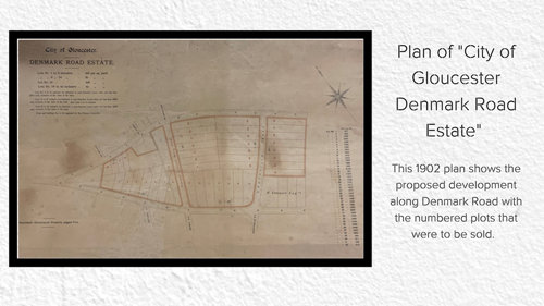
Plan of "City of Gloucester Denmark Road Estate" (D3651)
From the 1840s onwards Kingsholm underwent fairly rapid development – from 30 houses in 1801 to 363 by 1861. Working-class terraces sprung up north-east of Alvin Street, along Worcester Parade, St. Mark Street and Edwy Parade, while town houses and villas were built around newly formed Kingsholm Square. In the 1880s, Dean’s Walk and Dean’s Way were built and soon after several new roads were formed between Kingsholm and Wotton, allowing more housing to be built. In 1874 the city boundary was extended Kingsholm became a ward within the city, ostensibly to allow more improvements, especially to the sewage system. This 1902 plan shows the proposed development along Denmark Road with the numbered plots that were to be sold. Prices ranged from 4s 6d to 5s 6d per square yard (about £18 to £23) with individual lots ranging from not less than £400 to £900 (£31,000 to £70,500). The plots on the left hand side were eventually to become Denmark Road High School which opened on the site in 1909, having moved from its original location of Mynd House, which lay closer to the city centre.
Last reviewed: