Display 17 of 27
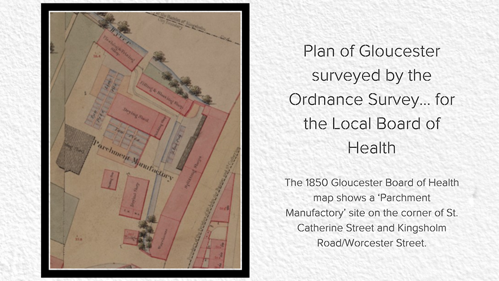
Plan of Gloucester surveyed by the Ordnance Survey... for the Local Board of Health'; map signed by Andrew Beatty, Captain, Royal Engineers (GBR/L10/1/2)
The 1850 Gloucester Board of Health map shows a ‘Parchment Manufactory’ site on the corner of St. Catherine Street and Kingsholm Road/Worcester Street. This had tanning pits, a fleshing and splitting shops, a fitting & shaving shop and drying sheds. Very little is known about the company that operated it, although it had closed by 1870. It would have made the area rather unpleasant in terms of the environment, especially the smell!
Last reviewed: