Display 3 of 19
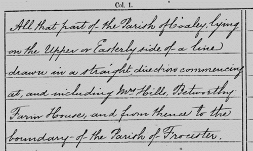
Enumerators routes – ‘All that part of….’, 1881 census enumerators route for part of the parish of Coaley
Some routes are more clear - this extract from the 1881 census for Coaley is for part of the village that lay ‘…on the Upper or Easterly side of a line drawn in a straight direction commencing at and including William Hills, Betworthy Farm House and from there to the boundary of the Parish of Frocester…’. Looking at this on a map such as the 1881 OS map – available to view on Know Your Place west (http://www.kypwest.org.uk/) – you can tell that this part of the census for Coaley only really covered the southerly part of the village.
Last reviewed: